Iowa-Parcels
Iowa Parcel Geospatial Data
This is a running list of sources of geospatial parcel data for Iowa counties. The linked data are provided “as is” without warranty or any representation of accuracy, timeliness or completeness. The burden or determining accuracy for the appropriateness for use rests solely on the user. Providers make no warranties, express or implied, as to the use of the data. The user acknowledges and accepts the limitations of the data, including the fact that the data are dynamic and in a constant state of maintenance and update.
How to filter and export statewide parcel data with QGIS
Make sure to scroll right at the bottom of this list to see all the columns
| geoid | county | service | parcels | iowagisdata | iowagisdata_notes | iowa_hs_em |
|---|---|---|---|---|---|---|
| 05000US19001 | Adair | https://wfs.schneidercorp.com/arcgis/rest/services/AdairCountyIA_WFS/MapServer | https://wfs.schneidercorp.com/arcgis/rest/services/AdairCountyIA_WFS/MapServer/0 | https://eoc.iowa.gov/arcgis/rest/services/Public/parcels_da/MapServer/0/query?where=countyname=%27ADAIR%27&returnGeometry=true&f=json&outFields=* | ||
| 05000US19003 | Adams | https://eoc.iowa.gov/arcgis/rest/services/Public/parcels_da/MapServer/0/query?where=countyname=%27ADAMS%27&returnGeometry=true&f=json&outFields=* | ||||
| 05000US19005 | Allamakee | https://eoc.iowa.gov/arcgis/rest/services/Public/parcels_da/MapServer/0/query?where=countyname=%27ALLAMAKEE%27&returnGeometry=true&f=json&outFields=* | ||||
| 05000US19007 | Appanoose | https://eoc.iowa.gov/arcgis/rest/services/Public/parcels_da/MapServer/0/query?where=countyname=%27APPANOOSE%27&returnGeometry=true&f=json&outFields=* | ||||
| 05000US19009 | Audubon | https://eoc.iowa.gov/arcgis/rest/services/Public/parcels_da/MapServer/0/query?where=countyname=%27AUDUBON%27&returnGeometry=true&f=json&outFields=* | ||||
| 05000US19011 | Benton | https://wfs.schneidercorp.com/arcgis/rest/services/BentonCountyIA_WFS/MapServer | https://wfs.schneidercorp.com/arcgis/rest/services/BentonCountyIA_WFS/MapServer/0 | https://eoc.iowa.gov/arcgis/rest/services/Public/parcels_da/MapServer/0/query?where=countyname=%27BENTON%27&returnGeometry=true&f=json&outFields=* | ||
| 05000US19013 | Black Hawk | https://services5.arcgis.com/ya62ECiavqTkK0wv/arcgis/rest/services | https://services5.arcgis.com/ya62ECiavqTkK0wv/arcgis/rest/services/ParcelData/FeatureServer | https://eoc.iowa.gov/arcgis/rest/services/Public/parcels_da/MapServer/0/query?where=countyname=%27BLACK HAWK%27&returnGeometry=true&f=json&outFields=* | ||
| 05000US19015 | Boone | https://www.iowagisdata.org/index.php/apps/files/files/232?dir=/County/Boone/Open | https://eoc.iowa.gov/arcgis/rest/services/Public/parcels_da/MapServer/0/query?where=countyname=%27BOONE%27&returnGeometry=true&f=json&outFields=* | |||
| 05000US19017 | Bremer | https://services8.arcgis.com/5fdnasK4g70Ve01j/arcgis/rest/services/Bremer_County_Reference_Map/FeatureServer | https://services8.arcgis.com/5fdnasK4g70Ve01j/ArcGIS/rest/services/Bremer_County_Reference_Map/FeatureServer/8 | https://eoc.iowa.gov/arcgis/rest/services/Public/parcels_da/MapServer/0/query?where=countyname=%27BREMER%27&returnGeometry=true&f=json&outFields=* | ||
| 05000US19019 | Buchanan | https://services2.arcgis.com/tYzMC5F5v21mpREX/arcgis/rest/services | https://services2.arcgis.com/tYzMC5F5v21mpREX/arcgis/rest/services/Parcel_data_all/FeatureServer | https://eoc.iowa.gov/arcgis/rest/services/Public/parcels_da/MapServer/0/query?where=countyname=%27BUCHANAN%27&returnGeometry=true&f=json&outFields=* | ||
| 05000US19021 | Buena Vista | https://wfs.schneidercorp.com/arcgis/rest/services/BuenaVistaCountyIA_WFS/MapServer | https://wfs.schneidercorp.com/arcgis/rest/services/BuenaVistaCountyIA_WFS/MapServer/1 | https://eoc.iowa.gov/arcgis/rest/services/Public/parcels_da/MapServer/0/query?where=countyname=%27BUENA VISTA%27&returnGeometry=true&f=json&outFields=* | ||
| 05000US19023 | Butler | https://services.arcgis.com/4YineAQdtmx0tv46/ArcGIS/rest/services/ButlerIAFeatures/FeatureServer | https://services.arcgis.com/4YineAQdtmx0tv46/ArcGIS/rest/services/ButlerIAFeatures/FeatureServer/3 | https://eoc.iowa.gov/arcgis/rest/services/Public/parcels_da/MapServer/0/query?where=countyname=%27BUTLER%27&returnGeometry=true&f=json&outFields=* | ||
| 05000US19025 | Calhoun | https://eoc.iowa.gov/arcgis/rest/services/Public/parcels_da/MapServer/0/query?where=countyname=%27CALHOUN%27&returnGeometry=true&f=json&outFields=* | ||||
| 05000US19027 | Carroll | https://eoc.iowa.gov/arcgis/rest/services/Public/parcels_da/MapServer/0/query?where=countyname=%27CARROLL%27&returnGeometry=true&f=json&outFields=* | ||||
| 05000US19029 | Cass | https://wfs.schneidercorp.com/arcgis/rest/services/CassCountyIA_WFS/MapServer | https://wfs.schneidercorp.com/arcgis/rest/services/CassCountyIA_WFS/MapServer/0 | https://eoc.iowa.gov/arcgis/rest/services/Public/parcels_da/MapServer/0/query?where=countyname=%27CASS%27&returnGeometry=true&f=json&outFields=* | ||
| 05000US19031 | Cedar | https://services.arcgis.com/PFvIQefqmvWD9XbB/ArcGIS/rest/services/Cedar_County_IA_Parcels_and_Muni/FeatureServer/1 | https://www.iowagisdata.org/index.php/apps/files/files/713?dir=/County/Cedar/Open | https://eoc.iowa.gov/arcgis/rest/services/Public/parcels_da/MapServer/0/query?where=countyname=%27CEDAR%27&returnGeometry=true&f=json&outFields=* | ||
| 05000US19033 | Cerro Gordo | https://wfs.schneidercorp.com/arcgis/rest/services/CerroGordoCountyIA_WFS/MapServer | https://wfs.schneidercorp.com/arcgis/rest/services/CerroGordoCountyIA_WFS/MapServer/0 | https://eoc.iowa.gov/arcgis/rest/services/Public/parcels_da/MapServer/0/query?where=countyname=%27CERRO GORDO%27&returnGeometry=true&f=json&outFields=* | ||
| 05000US19035 | Cherokee | https://www.iowagisdata.org/index.php/apps/files/files/715?dir=/County/Cherokee/Open | https://eoc.iowa.gov/arcgis/rest/services/Public/parcels_da/MapServer/0/query?where=countyname=%27CHEROKEE%27&returnGeometry=true&f=json&outFields=* | |||
| 05000US19037 | Chickasaw | https://wfs.schneidercorp.com/arcgis/rest/services/ChickasawCountyIA_WFS/MapServer | https://wfs.schneidercorp.com/arcgis/rest/services/ChickasawCountyIA_WFS/MapServer/0 | https://eoc.iowa.gov/arcgis/rest/services/Public/parcels_da/MapServer/0/query?where=countyname=%27CHICKASAW%27&returnGeometry=true&f=json&outFields=* | ||
| 05000US19039 | Clarke | https://eoc.iowa.gov/arcgis/rest/services/Public/parcels_da/MapServer/0/query?where=countyname=%27CLARKE%27&returnGeometry=true&f=json&outFields=* | ||||
| 05000US19041 | Clay | https://eoc.iowa.gov/arcgis/rest/services/Public/parcels_da/MapServer/0/query?where=countyname=%27CLAY%27&returnGeometry=true&f=json&outFields=* | ||||
| 05000US19043 | Clayton | https://services9.arcgis.com/jb7kNQO9B8zwLCAh/ArcGIS/rest/services/Clayton_County_Iowa_Stand_Maps_WFL1/FeatureServer/1 | https://www.iowagisdata.org/index.php/apps/files/files/719?dir=/County/Clayton/Open | https://eoc.iowa.gov/arcgis/rest/services/Public/parcels_da/MapServer/0/query?where=countyname=%27CLAYTON%27&returnGeometry=true&f=json&outFields=* | ||
| 05000US19045 | Clinton | https://eoc.iowa.gov/arcgis/rest/services/Public/parcels_da/MapServer/0/query?where=countyname=%27CLINTON%27&returnGeometry=true&f=json&outFields=* | ||||
| 05000US19047 | Crawford | https://services3.arcgis.com/uwUOPltmS5vV1WmH/ArcGIS/rest/services/CrawfordIAFeatures/FeatureServer | https://services3.arcgis.com/uwUOPltmS5vV1WmH/ArcGIS/rest/services/CrawfordIAFeatures/FeatureServer/6 | https://eoc.iowa.gov/arcgis/rest/services/Public/parcels_da/MapServer/0/query?where=countyname=%27CRAWFORD%27&returnGeometry=true&f=json&outFields=* | ||
| 05000US19049 | Dallas | https://gis.dallascountyiowa.gov/arcgis/rest/services | https://gis.dallascountyiowa.gov/arcgis/rest/services/Assessor/AssessorData/MapServer/89 | https://eoc.iowa.gov/arcgis/rest/services/Public/parcels_da/MapServer/0/query?where=countyname=%27DALLAS%27&returnGeometry=true&f=json&outFields=* | ||
| 05000US19051 | Davis | https://eoc.iowa.gov/arcgis/rest/services/Public/parcels_da/MapServer/0/query?where=countyname=%27DAVIS%27&returnGeometry=true&f=json&outFields=* | ||||
| 05000US19053 | Decatur | https://services.arcgis.com/4YineAQdtmx0tv46/ArcGIS/rest/services/DecaturIAFeatures/FeatureServer | https://services.arcgis.com/4YineAQdtmx0tv46/ArcGIS/rest/services/DecaturIAFeatures/FeatureServer/3 | https://eoc.iowa.gov/arcgis/rest/services/Public/parcels_da/MapServer/0/query?where=countyname=%27DECATUR%27&returnGeometry=true&f=json&outFields=* | ||
| 05000US19055 | Delaware | https://wfs.schneidercorp.com/arcgis/rest/services/DelawareCountyIA_WFS/MapServer | https://wfs.schneidercorp.com/arcgis/rest/services/DelawareCountyIA_WFS/MapServer/2 | https://www.iowagisdata.org/index.php/apps/files/files/350870?dir=/County/Delaware | https://eoc.iowa.gov/arcgis/rest/services/Public/parcels_da/MapServer/0/query?where=countyname=%27DELAWARE%27&returnGeometry=true&f=json&outFields=* | |
| 05000US19057 | Des Moines | https://www.dmcwebgis.com/arcgis/rest/services | https://www.dmcwebgis.com/arcgis/rest/services/Collector/ParcelCollector/MapServer | https://eoc.iowa.gov/arcgis/rest/services/Public/parcels_da/MapServer/0/query?where=countyname=%27DES MOINES%27&returnGeometry=true&f=json&outFields=* | ||
| 05000US19059 | Dickinson | https://www.iowagisdata.org/index.php/apps/files/files/768?dir=/County/Dickinson/Open | https://eoc.iowa.gov/arcgis/rest/services/Public/parcels_da/MapServer/0/query?where=countyname=%27DICKINSON%27&returnGeometry=true&f=json&outFields=* | |||
| 05000US19061 | Dubuque | https://gis.dbqco.org/arcgis/rest/services | https://gis.dbqco.org/arcgis/rest/services/Assessor/Reappraisal/MapServer | https://www.iowagisdata.org/index.php/apps/files/files/773?dir=/County/Dubuque/Open | https://eoc.iowa.gov/arcgis/rest/services/Public/parcels_da/MapServer/0/query?where=countyname=%27DUBUQUE%27&returnGeometry=true&f=json&outFields=* | |
| 05000US19063 | Emmet | https://eoc.iowa.gov/arcgis/rest/services/Public/parcels_da/MapServer/0/query?where=countyname=%27EMMET%27&returnGeometry=true&f=json&outFields=* | ||||
| 05000US19065 | Fayette | https://eoc.iowa.gov/arcgis/rest/services/Public/parcels_da/MapServer/0/query?where=countyname=%27FAYETTE%27&returnGeometry=true&f=json&outFields=* | ||||
| 05000US19067 | Floyd | https://eoc.iowa.gov/arcgis/rest/services/Public/parcels_da/MapServer/0/query?where=countyname=%27FLOYD%27&returnGeometry=true&f=json&outFields=* | ||||
| 05000US19069 | Franklin | https://www.iowagisdata.org/index.php/apps/files/files/786?dir=/County/Franklin/Open | no parcels | https://eoc.iowa.gov/arcgis/rest/services/Public/parcels_da/MapServer/0/query?where=countyname=%27FRANKLIN%27&returnGeometry=true&f=json&outFields=* | ||
| 05000US19071 | Fremont | https://www.iowagisdata.org/index.php/apps/files/files/793?dir=/County/Fremont/Open | https://eoc.iowa.gov/arcgis/rest/services/Public/parcels_da/MapServer/0/query?where=countyname=%27FREMONT%27&returnGeometry=true&f=json&outFields=* | |||
| 05000US19073 | Greene | https://eoc.iowa.gov/arcgis/rest/services/Public/parcels_da/MapServer/0/query?where=countyname=%27GREENE%27&returnGeometry=true&f=json&outFields=* | ||||
| 05000US19075 | Grundy | https://services7.arcgis.com/gdl6d769M9WXfbgM/arcgis/rest/services | https://services7.arcgis.com/gdl6d769M9WXfbgM/arcgis/rest/services/Grundy_County_Parcels/FeatureServer | https://www.iowagisdata.org/index.php/apps/files/files/245?dir=/County/Grundy | https://eoc.iowa.gov/arcgis/rest/services/Public/parcels_da/MapServer/0/query?where=countyname=%27GRUNDY%27&returnGeometry=true&f=json&outFields=* | |
| 05000US19077 | Guthrie | https://eoc.iowa.gov/arcgis/rest/services/Public/parcels_da/MapServer/0/query?where=countyname=%27GUTHRIE%27&returnGeometry=true&f=json&outFields=* | ||||
| 05000US19079 | Hamilton | https://www.iowagisdata.org/index.php/apps/files/files/36975?dir=/County/Hamilton/Open | https://eoc.iowa.gov/arcgis/rest/services/Public/parcels_da/MapServer/0/query?where=countyname=%27HAMILTON%27&returnGeometry=true&f=json&outFields=* | |||
| 05000US19081 | Hancock | https://eoc.iowa.gov/arcgis/rest/services/Public/parcels_da/MapServer/0/query?where=countyname=%27HANCOCK%27&returnGeometry=true&f=json&outFields=* | ||||
| 05000US19083 | Hardin | https://wfs.schneidercorp.com/arcgis/rest/services/HardinCountyIA_AGS/MapServer | https://wfs.schneidercorp.com/arcgis/rest/services/HardinCountyIA_AGS/MapServer/37 | https://www.iowagisdata.org/index.php/apps/files/files/248?dir=/County/Hardin | https://eoc.iowa.gov/arcgis/rest/services/Public/parcels_da/MapServer/0/query?where=countyname=%27HARDIN%27&returnGeometry=true&f=json&outFields=* | |
| 05000US19085 | Harrison | https://wfs.schneidercorp.com/arcgis/rest/services/HarrisonCountyIA_WFS/MapServer | https://wfs.schneidercorp.com/arcgis/rest/services/HarrisonCountyIA_WFS/MapServer/0 | https://www.iowagisdata.org/index.php/apps/files/files/833?dir=/County/Harrison/Open | no parcels | https://eoc.iowa.gov/arcgis/rest/services/Public/parcels_da/MapServer/0/query?where=countyname=%27HARRISON%27&returnGeometry=true&f=json&outFields=* |
| 05000US19087 | Henry | https://eoc.iowa.gov/arcgis/rest/services/Public/parcels_da/MapServer/0/query?where=countyname=%27HENRY%27&returnGeometry=true&f=json&outFields=* | ||||
| 05000US19089 | Howard | https://eoc.iowa.gov/arcgis/rest/services/Public/parcels_da/MapServer/0/query?where=countyname=%27HOWARD%27&returnGeometry=true&f=json&outFields=* | ||||
| 05000US19091 | Humboldt | https://wfs.schneidercorp.com/arcgis/rest/services/HumboldtCountyIA_WFS/MapServer | https://wfs.schneidercorp.com/arcgis/rest/services/HumboldtCountyIA_WFS/MapServer/0 | https://eoc.iowa.gov/arcgis/rest/services/Public/parcels_da/MapServer/0/query?where=countyname=%27HUMBOLDT%27&returnGeometry=true&f=json&outFields=* | ||
| 05000US19093 | Ida | https://eoc.iowa.gov/arcgis/rest/services/Public/parcels_da/MapServer/0/query?where=countyname=%27IDA%27&returnGeometry=true&f=json&outFields=* | ||||
| 05000US19095 | Iowa | https://wfs.schneidercorp.com/arcgis/rest/services/IowaCountyIA_WFS/MapServer | https://wfs.schneidercorp.com/arcgis/rest/services/IowaCountyIA_WFS/MapServer/0 | https://eoc.iowa.gov/arcgis/rest/services/Public/parcels_da/MapServer/0/query?where=countyname=%27IOWA%27&returnGeometry=true&f=json&outFields=* | ||
| 05000US19097 | Jackson | https://services9.arcgis.com/MwhmgVod3RReV4Us/arcgis/rest/services/Parcels/FeatureServer | https://www.iowagisdata.org/index.php/apps/files/files/840?dir=/County/Jackson/Open | https://eoc.iowa.gov/arcgis/rest/services/Public/parcels_da/MapServer/0/query?where=countyname=%27JACKSON%27&returnGeometry=true&f=json&outFields=* | ||
| 05000US19099 | Jasper | https://services7.arcgis.com/gw2LC2HdjEQbBIyL/ArcGIS/rest/services/County_Parcels_Public_View/FeatureServer/9 | https://www.iowagisdata.org/index.php/apps/files/files/251?dir=/County/Jasper | parcels in IowaOneCall zip | https://eoc.iowa.gov/arcgis/rest/services/Public/parcels_da/MapServer/0/query?where=countyname=%27JASPER%27&returnGeometry=true&f=json&outFields=* | |
| 05000US19101 | Jefferson | https://wfs.schneidercorp.com/arcgis/rest/services/JeffersonCountyIA_WFS/MapServer | https://wfs.schneidercorp.com/arcgis/rest/services/JeffersonCountyIA_WFS/MapServer/37 | https://eoc.iowa.gov/arcgis/rest/services/Public/parcels_da/MapServer/0/query?where=countyname=%27JEFFERSON%27&returnGeometry=true&f=json&outFields=* | ||
| 05000US19103 | Johnson | https://gis.johnsoncountyiowa.gov/arcgis/rest/services | https://gis.johnsoncountyiowa.gov/arcgis/rest/services/Parcels_WFS/MapServer/2 | https://www.iowagisdata.org/index.php/apps/files/files/854?dir=/County/Johnson/Open | https://eoc.iowa.gov/arcgis/rest/services/Public/parcels_da/MapServer/0/query?where=countyname=%27JOHNSON%27&returnGeometry=true&f=json&outFields=* | |
| 05000US19105 | Jones | https://eoc.iowa.gov/arcgis/rest/services/Public/parcels_da/MapServer/0/query?where=countyname=%27JONES%27&returnGeometry=true&f=json&outFields=* | ||||
| 05000US19107 | Keokuk | https://eoc.iowa.gov/arcgis/rest/services/Public/parcels_da/MapServer/0/query?where=countyname=%27KEOKUK%27&returnGeometry=true&f=json&outFields=* | ||||
| 05000US19109 | Kossuth | https://services.arcgis.com/4YineAQdtmx0tv46/ArcGIS/rest/services/KossuthIAFeatures/FeatureServer | https://services.arcgis.com/4YineAQdtmx0tv46/ArcGIS/rest/services/KossuthIAFeatures/FeatureServer/6 | https://eoc.iowa.gov/arcgis/rest/services/Public/parcels_da/MapServer/0/query?where=countyname=%27KOSSUTH%27&returnGeometry=true&f=json&outFields=* | ||
| 05000US19111 | Lee | https://services1.arcgis.com/DI59pGRbGVB0nAAA/ArcGIS/rest/services/PARCELS/FeatureServer | https://eoc.iowa.gov/arcgis/rest/services/Public/parcels_da/MapServer/0/query?where=countyname=%27LEE%27&returnGeometry=true&f=json&outFields=* | |||
| 05000US19113 | Linn | https://gis.linncountyiowa.gov/ags/rest/services | https://gis.linncountyiowa.gov/ags/rest/services/RealEstate/mapLandRecords/MapServer/15 | https://eoc.iowa.gov/arcgis/rest/services/Public/parcels_da/MapServer/0/query?where=countyname=%27LINN%27&returnGeometry=true&f=json&outFields=* | ||
| 05000US19115 | Louisa | https://wfs.schneidercorp.com/arcgis/rest/services/LouisaCountyIA_WFS/MapServer | https://wfs.schneidercorp.com/arcgis/rest/services/LouisaCountyIA_WFS/MapServer/0 | https://eoc.iowa.gov/arcgis/rest/services/Public/parcels_da/MapServer/0/query?where=countyname=%27LOUISA%27&returnGeometry=true&f=json&outFields=* | ||
| 05000US19117 | Lucas | https://eoc.iowa.gov/arcgis/rest/services/Public/parcels_da/MapServer/0/query?where=countyname=%27LUCAS%27&returnGeometry=true&f=json&outFields=* | ||||
| 05000US19119 | Lyon | https://wfs.schneidercorp.com/arcgis/rest/services/LyonCountyIA_WFS/MapServer | https://wfs.schneidercorp.com/arcgis/rest/services/LyonCountyIA_WFS/MapServer/0 | https://eoc.iowa.gov/arcgis/rest/services/Public/parcels_da/MapServer/0/query?where=countyname=%27LYON%27&returnGeometry=true&f=json&outFields=* | ||
| 05000US19121 | Madison | https://maps.dsm.city/p2/rest/services/External | https://maps.dsm.city/p2/rest/services/External/EXTDynamicShowMeMyHouse/MapServer/18 | https://eoc.iowa.gov/arcgis/rest/services/Public/parcels_da/MapServer/0/query?where=countyname=%27MADISON%27&returnGeometry=true&f=json&outFields=* | ||
| 05000US19123 | Mahaska | https://services7.arcgis.com/gw2LC2HdjEQbBIyL/ArcGIS/rest/services/County_Parcels_Public_View/FeatureServer/7 | https://eoc.iowa.gov/arcgis/rest/services/Public/parcels_da/MapServer/0/query?where=countyname=%27MAHASKA%27&returnGeometry=true&f=json&outFields=* | |||
| 05000US19125 | Marion | https://services7.arcgis.com/gw2LC2HdjEQbBIyL/ArcGIS/rest/services/County_Parcels_Public_View/FeatureServer/6 | https://eoc.iowa.gov/arcgis/rest/services/Public/parcels_da/MapServer/0/query?where=countyname=%27MARION%27&returnGeometry=true&f=json&outFields=* | |||
| 05000US19127 | Marshall | https://gis.marshallcountyia.gov/arcgis/rest/services | https://gis.marshallcountyia.gov/arcgis/rest/services/WebParcels/MapServer/0 | https://eoc.iowa.gov/arcgis/rest/services/Public/parcels_da/MapServer/0/query?where=countyname=%27MARSHALL%27&returnGeometry=true&f=json&outFields=* | ||
| 05000US19129 | Mills | https://services1.arcgis.com/20XE3PmEegLQbaze/arcgis/rest/services | https://services1.arcgis.com/20XE3PmEegLQbaze/ArcGIS/rest/services/Parcels/FeatureServer | https://eoc.iowa.gov/arcgis/rest/services/Public/parcels_da/MapServer/0/query?where=countyname=%27MILLS%27&returnGeometry=true&f=json&outFields=* | ||
| 05000US19131 | Mitchell | https://wfs.schneidercorp.com/arcgis/rest/services/MitchellCountyIA_WFS/MapServer | https://wfs.schneidercorp.com/arcgis/rest/services/MitchellCountyIA_WFS/MapServer/0 | https://eoc.iowa.gov/arcgis/rest/services/Public/parcels_da/MapServer/0/query?where=countyname=%27MITCHELL%27&returnGeometry=true&f=json&outFields=* | ||
| 05000US19133 | Monona | https://eoc.iowa.gov/arcgis/rest/services/Public/parcels_da/MapServer/0/query?where=countyname=%27MONONA%27&returnGeometry=true&f=json&outFields=* | ||||
| 05000US19135 | Monroe | https://eoc.iowa.gov/arcgis/rest/services/Public/parcels_da/MapServer/0/query?where=countyname=%27MONROE%27&returnGeometry=true&f=json&outFields=* | ||||
| 05000US19137 | Montgomery | https://eoc.iowa.gov/arcgis/rest/services/Public/parcels_da/MapServer/0/query?where=countyname=%27MONTGOMERY%27&returnGeometry=true&f=json&outFields=* | ||||
| 05000US19139 | Muscatine | https://magic-gis.com/arcgis/rest/services | https://magic-gis.com/arcgis/rest/services/MAGIC_Landbase/Countywide_ParcelLayers/FeatureServer | https://eoc.iowa.gov/arcgis/rest/services/Public/parcels_da/MapServer/0/query?where=countyname=%27MUSCATINE%27&returnGeometry=true&f=json&outFields=* | ||
| 05000US19141 | O’Brien | https://eoc.iowa.gov/arcgis/rest/services/Public/parcels_da/MapServer/0/query?where=countyname=%27O’BRIEN%27&returnGeometry=true&f=json&outFields=* | ||||
| 05000US19143 | Osceola | https://wfs.schneidercorp.com/arcgis/rest/services/OsceolaCountyIA_WFS/MapServer | https://wfs.schneidercorp.com/arcgis/rest/services/OsceolaCountyIA_WFS/MapServer/1 | https://eoc.iowa.gov/arcgis/rest/services/Public/parcels_da/MapServer/0/query?where=countyname=%27OSCEOLA%27&returnGeometry=true&f=json&outFields=* | ||
| 05000US19145 | Page | https://www.iowagisdata.org/index.php/apps/files/files/900?dir=/County/Page/Open | https://eoc.iowa.gov/arcgis/rest/services/Public/parcels_da/MapServer/0/query?where=countyname=%27PAGE%27&returnGeometry=true&f=json&outFields=* | |||
| 05000US19147 | Palo Alto | https://eoc.iowa.gov/arcgis/rest/services/Public/parcels_da/MapServer/0/query?where=countyname=%27PALO ALTO%27&returnGeometry=true&f=json&outFields=* | ||||
| 05000US19149 | Plymouth | https://eoc.iowa.gov/arcgis/rest/services/Public/parcels_da/MapServer/0/query?where=countyname=%27PLYMOUTH%27&returnGeometry=true&f=json&outFields=* | ||||
| 05000US19151 | Pocahontas | https://eoc.iowa.gov/arcgis/rest/services/Public/parcels_da/MapServer/0/query?where=countyname=%27POCAHONTAS%27&returnGeometry=true&f=json&outFields=* | ||||
| 05000US19153 | Polk | https://maps.dsm.city/p2/rest/services/External | https://maps.dsm.city/p2/rest/services/External/EXTDynamicShowMeMyHouse/MapServer/18 | https://www.iowagisdata.org/index.php/apps/files/files/914?dir=/County/Polk/Open | https://eoc.iowa.gov/arcgis/rest/services/Public/parcels_da/MapServer/0/query?where=countyname=%27POLK%27&returnGeometry=true&f=json&outFields=* | |
| 05000US19155 | Pottawattamie | https://gis.pottcounty-ia.gov/arcgis/rest/services | https://gis.pottcounty-ia.gov/arcgis/rest/services/OpenData/MapServer/0 | https://www.iowagisdata.org/index.php/apps/files/files/919?dir=/County/Pottawattamie/Open | https://eoc.iowa.gov/arcgis/rest/services/Public/parcels_da/MapServer/0/query?where=countyname=%27POTTAWATTAMIE%27&returnGeometry=true&f=json&outFields=* | |
| 05000US19157 | Poweshiek | https://services7.arcgis.com/gw2LC2HdjEQbBIyL/ArcGIS/rest/services/County_Parcels_Public_View/FeatureServer/8 | https://www.iowagisdata.org/index.php/apps/files/files/926?dir=/County/Poweshiek/Open | https://eoc.iowa.gov/arcgis/rest/services/Public/parcels_da/MapServer/0/query?where=countyname=%27POWESHIEK%27&returnGeometry=true&f=json&outFields=* | ||
| 05000US19159 | Ringgold | https://services8.arcgis.com/mB38qVcGOm8ztiWD/arcgis/rest/services/Ringgold_County/FeatureServer | https://eoc.iowa.gov/arcgis/rest/services/Public/parcels_da/MapServer/0/query?where=countyname=%27RINGGOLD%27&returnGeometry=true&f=json&outFields=* | |||
| 05000US19161 | Sac | https://eoc.iowa.gov/arcgis/rest/services/Public/parcels_da/MapServer/0/query?where=countyname=%27SAC%27&returnGeometry=true&f=json&outFields=* | ||||
| 05000US19163 | Scott | https://services.arcgis.com/ovln19YRWV44nBqV/arcgis/rest/services/ | https://services.arcgis.com/ovln19YRWV44nBqV/ArcGIS/rest/services/Cadastral/FeatureServer/3 | https://www.iowagisdata.org/index.php/apps/files/files/935?dir=/County/Scott/Open | https://eoc.iowa.gov/arcgis/rest/services/Public/parcels_da/MapServer/0/query?where=countyname=%27SCOTT%27&returnGeometry=true&f=json&outFields=* | |
| 05000US19165 | Shelby | https://eoc.iowa.gov/arcgis/rest/services/Public/parcels_da/MapServer/0/query?where=countyname=%27SHELBY%27&returnGeometry=true&f=json&outFields=* | ||||
| 05000US19167 | Sioux | https://eoc.iowa.gov/arcgis/rest/services/Public/parcels_da/MapServer/0/query?where=countyname=%27SIOUX%27&returnGeometry=true&f=json&outFields=* | ||||
| 05000US19169 | Story | https://apps.storycounty.com/arcgis/rest/services | https://apps.storycounty.com/arcgis/rest/services/parcels/MapServer | https://www.iowagisdata.org/index.php/apps/files/files/947?dir=/County/Story/Open | https://eoc.iowa.gov/arcgis/rest/services/Public/parcels_da/MapServer/0/query?where=countyname=%27STORY%27&returnGeometry=true&f=json&outFields=* | |
| 05000US19171 | Tama | https://eoc.iowa.gov/arcgis/rest/services/Public/parcels_da/MapServer/0/query?where=countyname=%27TAMA%27&returnGeometry=true&f=json&outFields=* | ||||
| 05000US19173 | Taylor | https://eoc.iowa.gov/arcgis/rest/services/Public/parcels_da/MapServer/0/query?where=countyname=%27TAYLOR%27&returnGeometry=true&f=json&outFields=* | ||||
| 05000US19175 | Union | https://eoc.iowa.gov/arcgis/rest/services/Public/parcels_da/MapServer/0/query?where=countyname=%27UNION%27&returnGeometry=true&f=json&outFields=* | ||||
| 05000US19177 | Van Buren | https://eoc.iowa.gov/arcgis/rest/services/Public/parcels_da/MapServer/0/query?where=countyname=%27VAN BUREN%27&returnGeometry=true&f=json&outFields=* | ||||
| 05000US19179 | Wapello | https://wfs.schneidercorp.com/arcgis/rest/services/WapelloCountyIA_WFS/MapServer | https://wfs.schneidercorp.com/arcgis/rest/services/WapelloCountyIA_WFS/MapServer/0 | https://eoc.iowa.gov/arcgis/rest/services/Public/parcels_da/MapServer/0/query?where=countyname=%27WAPELLO%27&returnGeometry=true&f=json&outFields=* | ||
| 05000US19181 | Warren | https://maps.dsm.city/p2/rest/services/External | https://maps.dsm.city/p2/rest/services/External/EXTDynamicShowMeMyHouse/MapServer/18 | https://eoc.iowa.gov/arcgis/rest/services/Public/parcels_da/MapServer/0/query?where=countyname=%27WARREN%27&returnGeometry=true&f=json&outFields=* | ||
| 05000US19183 | Washington | https://www.iowagisdata.org/index.php/apps/files/files/968?dir=/County/Washington/Open | https://eoc.iowa.gov/arcgis/rest/services/Public/parcels_da/MapServer/0/query?where=countyname=%27WASHINGTON%27&returnGeometry=true&f=json&outFields=* | |||
| 05000US19185 | Wayne | https://services8.arcgis.com/PrsPdsflms4LbDeT/arcgis/rest/services/Outstanding_Taxes/FeatureServer; https://services8.arcgis.com/PrsPdsflms4LbDeT/ArcGIS/rest/services/Wayne_County_Vacant_Parcels/FeatureServer | https://eoc.iowa.gov/arcgis/rest/services/Public/parcels_da/MapServer/0/query?where=countyname=%27WAYNE%27&returnGeometry=true&f=json&outFields=* | |||
| 05000US19187 | Webster | https://www.iowagisdata.org/index.php/apps/files/files/975?dir=/County/Webster/Open | https://eoc.iowa.gov/arcgis/rest/services/Public/parcels_da/MapServer/0/query?where=countyname=%27WEBSTER%27&returnGeometry=true&f=json&outFields=* | |||
| 05000US19189 | Winnebago | https://wfs.schneidercorp.com/arcgis/rest/services/WinnebagoCountyIA_WFS/MapServer | https://wfs.schneidercorp.com/arcgis/rest/services/WinnebagoCountyIA_WFS/MapServer/12 | https://eoc.iowa.gov/arcgis/rest/services/Public/parcels_da/MapServer/0/query?where=countyname=%27WINNEBAGO%27&returnGeometry=true&f=json&outFields=* | ||
| 05000US19191 | Winneshiek | https://www.iowagisdata.org/index.php/apps/files/files/982?dir=/County/Winneshiek/Open | https://eoc.iowa.gov/arcgis/rest/services/Public/parcels_da/MapServer/0/query?where=countyname=%27WINNESHIEK%27&returnGeometry=true&f=json&outFields=* | |||
| 05000US19193 | Woodbury | https://maps.wcicc.com:6443/arcgis/rest/services | https://maps.wcicc.com:6443/arcgis/rest/services/ParcelDataFlex/MapServer/0 | https://eoc.iowa.gov/arcgis/rest/services/Public/parcels_da/MapServer/0/query?where=countyname=%27WOODBURY%27&returnGeometry=true&f=json&outFields=* | ||
| 05000US19195 | Worth | https://wfs.schneidercorp.com/arcgis/rest/services/WorthCountyIA_WFS/MapServer | https://wfs.schneidercorp.com/arcgis/rest/services/WorthCountyIA_WFS/MapServer/0 | https://eoc.iowa.gov/arcgis/rest/services/Public/parcels_da/MapServer/0/query?where=countyname=%27WORTH%27&returnGeometry=true&f=json&outFields=* | ||
| 05000US19197 | Wright | https://wfs.schneidercorp.com/arcgis/rest/services/WrightCountyIA_WFS/MapServer | https://wfs.schneidercorp.com/arcgis/rest/services/WrightCountyIA_WFS/MapServer/2 | https://eoc.iowa.gov/arcgis/rest/services/Public/parcels_da/MapServer/0/query?where=countyname=%27WRIGHT%27&returnGeometry=true&f=json&outFields=* |
scroll right to see more columns
How to Add and Filter Data from the Statewide Parcel Data Server in QGIS
-
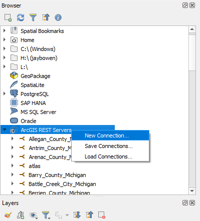
In the “Browser” window at the upper left, right click “ArcGIS REST Servers” and click “New Connection.”
-
Make a name for your connection and add the url to the service in the respective boxes. Click OK.

-
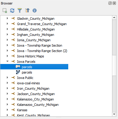
Scroll down to your connected service in the “Browser” window. Click the dropdown arrow and drag and drop “parcels” into the map window.
-
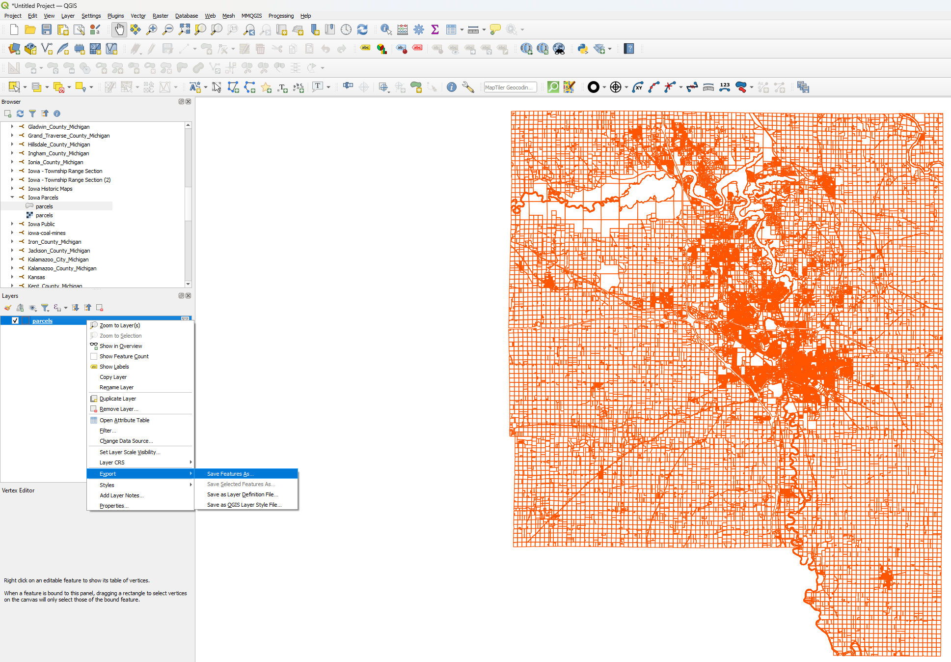
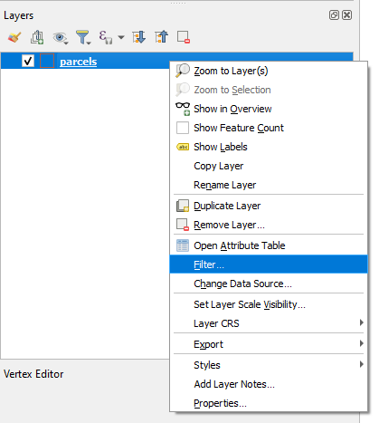
As the data loads in the map window, right click on “parcels” in the “Layers” window. Click “Filter” in the dropdown menu.
-
In the Query Builder form that opens, add a code in the following format to filter for your desired county: “countyname” = ‘JOHNSON’. The county names are in all caps. Click “OK.”

-
You should see the parcels for that county appear in the map window. If not, right click the layer and select “Zoom to layer(s).” To export, you can right click the layer, click “Export,” and click “Save features as” as usual.